5 Day Itinerary Clyde to Middlemarch

Our Recommendation: Day 1/Night 1 ( start Clyde finish Omakau/Ophir)

The Intercity bus from Queenstown drops you in Clyde. With a earlyish start and, of course, depending on fitness and cycling skills or whether your hire bike is electric assist, it’s not overstretching to book your first night’s accommodation at Omakau/Ophir.

If you arrive in the afternoon we suggest staying in historic and quaint Clyde or Alexandra and then following our advice above for Day 1/Night 1 on the Otago Central Rail Trail.

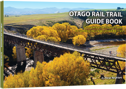
Some things to look forward to on your first day at our Muttontown viaduct, the Manuherikia River and the famous Tiger Hill.


Your Journey on Day 1

Click on the tabs below for info on the trail and distances between them.

Clyde to Alexandra   Distance: 8 km

  • From the Clyde Historic Precinct, along greenways and then through the State Highway 8 Daphne Hull Underpass will get you to the Clyde Trailhead. In the underpass do pause to admire the fantastic Bruce Potter mural lining the walls.  
  • Free long term parking is available at the Trailhead. There is also a well-maintained public toilet block.
  • A highlight on the Clyde-Alexandra section is the 109 metres long and 9 metres tall Muttontown wooden trestle viaduct.
  • After the Muttontown Viaduct you will see one of the last remaining signal arms on what was the Otago Central Railway.
  • On the outskirts of Alexandra, the Rail Trail runs parallel to the greens and fairways of the Alexandra Golf Club 18 hole course.

Alexandra to Chatto Creek   Distance: 17 km 

  • Leaving Alexandra, the Rail Trail crosses State Highway 85 to the Manuherikia Bridge No. 3.
  • Next highlight is Galloway Straight where part of the railway station building remains. This makes a popular stopping and meeting point for cyclists and support vehicles.
  • At the end of the straight is the first of the Rail Trail’s red painted Line Gangers’ Sheds. Inside each is a large information panel about the local area.
  • Keep an eye out for colourful lupines flowering over the spring and summer seasons.
  • Next up, the trail goes over the impressive 120 metres long and 14 metres high Manuherikia No. 2 Bridge. From the bridge you can try spotting trout or on a hot summer’s day, take a dip in the river.
  • Leaving the Manuherikia River you now follow the sublime Chatto Creek. Willows line the stream to the left and depending on the season, you will see and smell thyme spread amongst schist rock formations on the right.
  • Chatto Creek Tavern will draw you in with their fine food and friendly service.

Chatto Creek to Omakau   Distance: 12 km 

  • This section starts by crossing State Highway 85 from the Chatto Creek Tavern to an information kiosk and DOC toilet.
  • The trail soon ‘S’ bends up Tiger Hill. The steepest part of the Otago Rail Trail, this gradual 1 in 50 incline made it possible for the trains to climb up Tiger Hill.
  • Have a well-deserved rest at Tiger Hill Gangers’ Shed to enjoy spectacular mountain views.
  • After riding under the State Highway 8 overbridge it's a gentle downhill run to Omakau, once Central Otago’s largest stock loading railway station.

Our Recommendation: Day 2/Night 2 ( start Omakau/Ophir finish Oturehua )

We recommend pedaling no further than Oturehua for your second night’s stopover.

Highlights of Day 2 include Poolburn Gorge with its curved concrete bridge just out of Lauder, two long tunnels (don’t forget to bring a torch) and lofty railway viaduct not to mention stunning views and the chance of spying a kārearea, the NZ native falcon and world’s fastest diving bird of prey.


Your Journey on Day 2

Click on the tabs below for info on the trail and distances between them.

Omakau to Lauder   Distance: 7 km 

  • Between Omakau and Lauder the Rail Trail passes through the Matakanui Valley where pivot irrigators have turned this into productive deer, sheep and cattle country.
  • The snow-capped Dunstan Mountains can be easily viewed to the nor-west.
  •  The distinctive Hawkdun Mountain Range is also visible to the north.
  • The Raggedy Range is to the south east of the trail.
  • In Lauder you can breathe some of the world’s cleanest, most pollution-free air.

Lauder to Oturehua   Distance: 23 km 

  • After crossing State Highway 85, the trail takes you over the Manuherikia Bridge No. 1. An impressive curved concrete structure 110.6 metres long and 14 metres tall.
  • Approximately 10 metres before entering the Poolburn Tunnel No. 2, on the left is a path with a safety rail that takes you to remnants of the Linemen’s Base used during rail construction in the Poolburn Gorge.
  • It is hard not to feel sympathy for the linemen who built the railway using hard physical labour, wheelbarrow, pick, shovel, horse and cart.
  • Returning to the trail, switch on your torch and walk your bike through the Poolburn Tunnel No. 2. At 229 metres it’s the Rail Trail’s longest.
  • Further up the gorge is the Poolburn Tunnel 1. Because the railway was built from Middlemarch, this was the first of the two Poolburn Gorge tunnels.
  • Back into daylight it’s only a short distance to the 37 metre high Poolburn Viaduct, arguably the most imposing structure on the Rail Trail.
  • The viaduct’s huge rock piers and abutments were quarried from local outcrops and crafted by stone masons to a standard seldom seen today.
  • Be sure to read the information panel at the eastern (Oturehua) end of the viaduct.
  • Descending the slopes of this northern part of Raggedy Range, you are treated to brilliant views of the spectacular Hawkdun Mountain Range and North Rough Ridge.
  • After leaving the Poolburn Gorge, and having possibly caught a glimpse of the swept-wing New Zealand native falcon (karearea), you reach the Auripo Station where today nothing much remains.
  • The Ida Valley opens up in front of you. Known for its extremely harsh climate, during winter months, the valley floor is often cloaked in thick fog. .
  • Be sure to stop to take a look at the now privately owned Ida Valley Railway Hotel. This historic building is easily viewed from the trail or public road.
  • On the outskirts of Oturehua the trail crosses Ida Valley Road to the Idaburn Dam. During cold winters the dam can freeze to a depth suitable for curling competitions and when conditions are perfect, a curling bonspiel.
  • Just along from Idaburn Dam and back across the Ida Valley Road is the clearly signposted Hayes Engineering Works and Homestead (look for the windmill). Here Ernest Hayes forged many labour-saving inventions with his most famous being the Hayes Wire Strainer. Perfected in 1924, it is still used on fences throughout the world. The historic mud brick buildings are very photogenic.

Our Recommendation: Day 3/Night 3 ( start Oturehua finish Ranfurly or Waipiata)

Day 3 takes you across the ‘big sky’ country of the Maniototo to Ranfurly or Waipiata 8km further along the Rail Trail.

Night 3 is an opportunity to give curling a go in Naseby and perhaps even stay the night. There is a shuttle service to collect you from the Rail Trail at Wedderburn and deliver you back in the morning( Naseby Transfers : 03 444 9884 / 027 464 6337 ). There is also a car rental option from Wedderburn which gives you added flexibility ( Trail Rentals : 03 444 9504 / 021 0222 3314 ).


Your Journey on Day 3

Click on the tabs below for info on the trail and distances between them.

Oturehua to Wedderburn   Distance: 12 km 

  • Be sure not to leave Oturehua without visiting Gilchrist Store that’s been in business since 1899.
  • On Oturehua’s northern outskirts is the first of two 45º South Latitude markers on the trail to Wedderburn. 45 south puts you halfway between the Equator and South Pole.
  • Where the trail crosses Reef Road there’s a short and worthwhile detour to the historic Golden Progress Mine where Otago’s only remaining ‘poppet head’ straddles the deep shaft used for bringing gold-bearing ore to the surface.
  • After a gradual climb up Rough Ridge, you will come to a second 45º South Latitude marker.
  • Further on, take a breather at Seagull Hill Gangers’ Shed.
  • On the top of the ridge you’ll have reached 618 metres above sea level. And that means you’ve conquered the highest point of the Otago Central Rail Trail.
  • An easy slope takes you to the tiny town of Wedderburn boasting a 9-hole golf course and quaint country pub.
  • On leaving Wedderburn, the trail crosses SH 85 to the iconic Wedderburn goods shed made famous by eminent Central Otago artist, Grahame Sydney.

Wedderburn to Ranfurly   Distance: 13 km 

  • The trail from Wedderburn to Ranfurly is pretty much a downhill cruise across the vast Maniototo Plain surrounded by the Mt Ida, Rough Ridge, Hawkdun and Rock and Pillar Ranges, as well as the Kakanui Mountains. During winter and spring, these mountains are mostly snow-covered in winter and spring.
  • Two gangers’ sheds along this section of the Trail provide shelter and interesting reading about the local area and what lies ahead on the Rail Trail.
  • Ranfurly is the districts main rural supply and services centre and is also recognised for its many Art Deco buildings. For Rail Trailers it may come in handy to know Ranfurly also has a modern hospital and on the main street, a large pharmacy.

Ranfurly to Waipiata   Distance: 8 km

  • The Ranfurly to Waipiata section of the trail is in the heart of the Maniototo Plain. The Plain's vastness and the “big sky” create an undeniable sense of serenity. “Mani-o-toto” is Maori for “Plains of Blood”. This could be because of bloody incidents of the distant past, the slaughter of the Moa or the red colour of the landscape at sunset and sunrise.
  • Surrounding mountain ranges include the Rock and Pillar Range to the south, Rough Ridge to the west, Mt St Bathans to the nor-west, the Kakanui Mountains to the east and Mt Ida and the Mount Ida Range to the north. The contrast between the vastness of the plain, the mountains and the big Maniototo sky is spectacular. 
  • Find shade at the Ranfurly Straight Gangers’ Shed with information about the local area.
  • An underpass tells you that you are almost at Waipiata, a small town with a surprising number of accommodation choices and things to see and do.

Our Recommendation: Day 4/Night 4 (start Ranfurly or Waipiata finish Hyde) 

Reaching Hyde can present yet another ‘must-see’ opportunity and that is to visit the huge, fully operational Oceana Gold Mine on the outskirts of historic Macraes Flat. Stanley’s is the only accommodation in Macraes and like so many historic country hotels has a limited number of beds, so do book months rather than weeks in advance.


Your Journey on Day 4

Click on the tabs below for info on the trail and distances between them.

Waipiata to Kokonga   Distance: 10.5 km

  • The 97m long and 6m high Taieri River Rail Bridge is the Rail Trail's only crossing of the Taieri River, New Zealand's fourth longest river. 
  • A short distance along the trail from the bridge is one of the only “freedom camping areas” on the Otago Central Rail Trail. No  running water available. No fires.
  • Catch a trout for tea from the banks of the Taieri River.
  • Read the display boards about the naturally formed Lake Taieri which was drained in the 1940’s.
  • Observe the pitted volcanic rocks blown from the extinct Flat Cap Volcano beside the trail.
  • The Waipiata to Kokonga Road runs parallel to the Rail Trail at one point and physically crosses the Trail further down the line, known locally as Carey’s Crossing.
  • Further along is the town of Kokonga with a small settlement of houses below the trail.
  • The Gangers shed at Kokonga can be also be accessed from State Highway 87 (sign-posted 'Rail Trail Road').
  • The Kokonga Railway Station and Goods Shed have been removed but the concrete sided platform still remains.

Kokonga - Dasiybank Car Park 4km

  • From Kokonga the Trail runs adjacent to State Highway 87. Take time to admire the impressive Kakanui Mountains to the east.
  • The Daisybank car park is another convenient place to meet up with support vehicles. It is clearly signposted on State Highway 87 and on the Rail Trail itself. 

Daisy Bank Car Park - Tiroiti 4 km

  • Look and also listen carefully for traffic before crossing the sweeping corner of State Highway 87 at Daisybank.
  • You are now entering the dramatic terrain of the Upper Taieri Gorge. The many cuts and fills that make the trail easy for cyclists today show just how difficult it was to construct the Otago Central Railway back in the days of the pick, shovel and wheelbarrow.
  • A remaining feature of the railway’s early days is the Red Dwarf Gangers Shed. Poking your head out of the shed’s little window is a fun photo opportunity.
  • Not far from here is the Daisybank Freedom Camping site. No open fires are permitted during the closed season. No running water but there is a DOC toilet. Contact DOC for more information. It is recommended hopping off your bike to walk through the pines to the banks of the river at the camping area. Depending on the time of year, take a refreshing plunge in the Taieri.
  • A couple of km’s later at the Tiroiti station site is a railway red gangers’ shed and information kiosk. Between 1895 and 1897 there was a major railway construction camp at Tiroiti.

Tiroiti - Hyde 6.5 km

  • Not far from Tiroiti is the 40 metres long, 7 metres tall Cap Burn Railway Bridge. We recommend taking time to examine the historic dressed stone abutments and iron trusses as well as the original sleepers and railway lines. .
  • Next you’ll cross the 91 metres long and 32 metres high Prices Creek Viaduct. Built of concrete and steel in 1963 to replace a wooden bridge, it was the last major construction project before the railway closed. Cyclists should be aware of strong wind gusts when crossing the viaduct.
  • An alternative route for horseback riders is signposted on both ends of the viaduct.
  • The attractions keep coming with the 151 metres long slightly curved Prices Creek (Hyde) Tunnel, the only completely bricked tunnel on the Rail Trail.
  • Close to the tunnel entry a walkway leads down to the Taieri River for a close up view of the Hyde diversion tunnel. By diverting a section of river, miners believed gold could be plucked from the dry river bed. Unfortunately none was found. The walkway offers stunning scenery, interesting history, and great photo opportunities (highly recommended).
  • After the Prices Creek (Hyde) Tunnel, a gentle gradient takes you to the township of Hyde where there is a public car park, information kiosk and food and refreshment.

Our Recommendation: Day 5 ( start Hyde finish Middlemarch )

You will peddle through the scenic Strath Taieri Valley which is mostly downhill. Most shuttles leave Middlemarch early afternoon. 

  • The most popular option is to arrive in Middlemarch in time for your Bike Hire company / Tour Operators  to drive you back to Clyde to overnight there or connect with the Intercity bus from Clyde to Queenstown. The Intercity bus does not go through Middlemarch. The only place cyclists can use it is between Clyde/Alexandra to Queenstown. (Intercity Bus Timetable).
  • Dunedin takes some beating as a destination and a day or longer in ‘Edinburgh of the South’ is definitely worth consideration. Some Bike Hire Companies/ Tour Operators run on demand shuttles from Middlemarch to Dunedin Airport and Dunedin city. This must be booked well in advance. 
  • Staying in Middlemarch for a night is definitely an option. There’s a good selection of accommodation and interesting attractions such as a goldmining submarine, albeit unsuccessful. 

Your Journey on Day 5

Click on the tabs below for info on the trail and distances between them.

Hyde to Middlemarch   Distance: 27 km 

  • The section from Hyde to Middlemarch can be prone to strong winds, especially over spring and summer seasons. Generally though, winds are from the north which means a helping push. But should there be a head wind, you can take a break to rest and read the information panels in four gangers’ sheds:-  Scrub Burn, Rock and Pillar Access, Strath Taieri and Rock and Pillar Station .
  • Due to a lack of flat land at Hyde, the station is 2km down the line. Here is a well maintained station building and a number of original stock wagons. The station site also has road access from State Highway 87.
  • Past the Hyde Station is ‘Straw Cutting’, site of the Hyde railway derailment that on June 4th, 1943 claimed 21 lives and injured 46. Around 200 metres along the trail from here is a memorial area with a commemorative stone cairn. This also makes a convenient meeting place for Rail Trail cyclists and support vehicles.
  • As you approach the flatter farmland of the Strath Taieri Plain you’ll ride over Five Mile Creek, the rail’s last substantial bridge.
  • The Strath Taieri is flanked by the majestic Rock and Pillar Range to the nor-west and Taieri Ridge to the south-east.
  • Another good meeting point for support vehicles and cyclists is at the Rock and Pillar Gangers Shed where the Rail Trail crosses State Highway 87.
  • Regardless of wind direction, it is rewarding sight to see Middlemarch getting closer and closer, and where fine food, beverages and country hospitality await you.
  • Congratulations. You’ve done it. 153km.  

The Rail Trail Guide Book

The single most important resource when travelling the Central Otago Rail Trail

A beautifully crafted book with amazing photography by Peter Andrews showing Central Otago as it truly is, one of the most rugged, extreme and beautiful locations on the planet. Stunning scenery, amazing and important historical and current information, detailed maps, lists of accommodation, frequently asked questions, where to eat, how far between towns, etc. It’s all in here.

More Info